Output formats
TIFF Images
Resource | Bit depth | Channels |
|---|---|---|
DSM Image (height image) | 32 - floating | 1 |
DSM Metainformation layers (e.g. Standard Deviation, Number of Stereo Models, etc.) | 8, 32 | 1, 3 |
True Ortho | 8/16 - unsigned short | 1, 3, 4 |
Tiling
All TIFF products generated by SURE are tiled using 256 x 256 pixel blocks. Tiling improves access to the data whenever only parts of the data are required by the application.
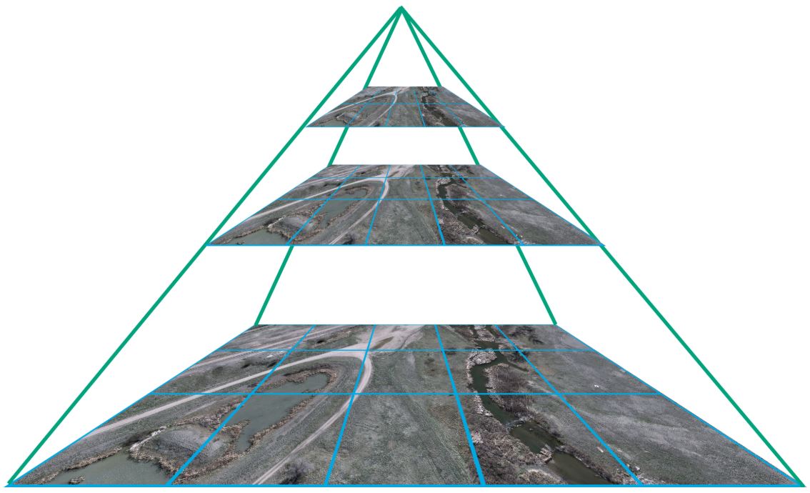
Pyramids
All TIFF products generated by SURE contain image pyramids by default. The generation of image pyramids can be enabled/disabled using the Advanced Configuration panel.
Pyramids greatly improve the work on GIS applications by allowing the customer to interact efficiently with large datasets. The file size of TIFF images increases by roughly 33% when using pyramids.
GeoTIFF Tag
The GeoTIFF tags are geo-referencing information stored inside the TIFF images. SURE always writes the GeoTIFF tags. The coordinates stored in the tag refer to the top left corner of the top-left pixel.
TIFF World Files (tfw)
In case the GeoTIFF tags cannot be interpreted by some GIS software or the GeoTIFF tags are lost during post-processing, additional *.tfw files are written next to the TIFF images. The writing of .tfw files can be enabled/disabled in the Advanced Configuration. By convention, the coordinates stored in the files point to the center of the top-left pixel. Note that there is an offset of half a pixel between the coordinates in the *.tfw file and the corresponding GeoTIFF tag.
VRT File
For each image (TIFF) based product type, the product folder will include a product_type.vrt file. This XML based file includes a reference to each raster tile in the product folder. The VRT File can be used to simply load a complete dataset in GIS applications such as ArcGIS Pro or QGIS.
“No Data” Tag
Images will be written with a NODATA tag. This tells the GIS software that a specific value (e.g. NaN) should be interpreted as a pixel with missing data.
Point Clouds
Resource | Format | Type |
|---|---|---|
LAZ, LAS | 2.5D | |
LAZ, LAS | 3D |
SURE uses the following LAS format definition: Las format definition. By default SURE writes all Point Clouds in the compressed LAZ format. Yet, export in .las format is still an available option.
Mesh
Resource | Format | Description |
|---|---|---|
Results/DSM_Mesh_For_Editing |
|
|
|
| |
|
| |
|
| |
|
|
Level-of-detail (LOD) allows you to efficiently stream large textured meshes through the web. This is done by only loading data depending on the zoom level of the viewer.
Even after the processing is finished, it is possible to use the Mesh Converter (GUI and CLI) for converting the OSGB meshes to any supported mesh format.
Draco compression is now disabled by default for the 3D Tiles (OGC/Cesium) Mesh results because it can negatively affect the performance when viewing the results with low-end hardware. For applying this optimization to existing projects, please disable Draco manually and restart (mesh) processing.
Supported texture formats:
Mesh format | Texture format (bold = default) |
|---|---|
osgb | s3tc |
3d_tiles | jpg / s3tc |
slpk | jpg & dds / jpg |
obj / dae | jpg / png |
lod_dae / lod_obj | jpg / png / dds |
local_obj | jpg / png |